


Dimension raquettes

Chabard
User

Length
12.9 km

Max alt
1775 m

Uphill gradient
924 m
Km-Effort
25 km

Min alt
1230 m

Downhill gradient
926 m
Boucle
Yes
Creation date :
2021-02-19 11:52:32.0
Updated on :
2021-02-19 16:17:35.996
4h24
Difficulty : Unknown

FREE GPS app for hiking
 SityTrail
IGN / Geographical institutes
SityTrail Plus
The world is yours!
About
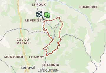
Trail Snowshoes of 12.9 km to be discovered at Auvergne-Rhône-Alpes, Upper Savoy, Les Clefs. This trail is proposed by Chabard.
Description
Rando raquette départ plan bois petit Sulens col de la botte plan du tourteau
Positioning
Country:
France
Region :
Auvergne-Rhône-Alpes
Department/Province :
Upper Savoy
Municipality :
Les Clefs
Location:
Unknown
Start:(Dec)
Start:(UTM)
294861 ; 5079630 (32T) N.
Comments